 AVYCAST
Queenstown — Avalanche Forecast
Avalanche danger in Queenstown (New Zealand) is 2 — Moderate, valid for Sunday, October 11, 2026. Published by New Zealand Avalanche Advisory.
High temps continue! Expect wet snow problems in all areas.
Danger by Elevation
Active Avalanche Problems

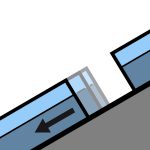
Recent reports of loose wet avalanches in steep South facing terrain. Although small, they were very easily triggered. Moderate westerlies and very warm. FAFL 3000m. Avoid shady aspects first thing unless prepared with the appropriate equipment.
Summer like heat is making its way into all aspects and elevations at the moment. Even normally shady areas - South aspects at upper elevations - are becoming wet in the afternoons. Expect a crust in the morning that will break down quickly in all areas.
Source: New Zealand Avalanche Advisory · View Original Bulletin
Original (EN)
Frequently asked questions
What does avalanche danger level 2 (Moderate) mean?
Heightened avalanche conditions on some steep slopes — careful route selection and terrain evaluation are needed.
How often is the Queenstown forecast updated?
Avycast refreshes hourly; the bulletin is republished by New Zealand Avalanche Advisory usually once a day during the season.
Who publishes the Queenstown avalanche forecast?
New Zealand Avalanche Advisory — the official warning service. Avycast aggregates and translates it; always check the original bulletin.
Nearby Regions
- Wanaka · 28 km
- Aspiring · 53 km
- Fiordland · 91 km
- Ohau · 101 km
- Aoraki/Mt Cook · 173 km
- Two Thumbs · 188 km