 AVYCAST
Queenstown — Bulletin d'avalanche
Le danger d'avalanche en Queenstown (Nouvelle-Zélande) est 2 — Limité, valable pour dimanche 11 octobre 2026. Publié par New Zealand Avalanche Advisory.
Traduction en cours — affiché en langue source
High temps continue! Expect wet snow problems in all areas.
Danger par altitude
Problèmes d'avalanches actifs

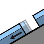
Recent reports of loose wet avalanches in steep South facing terrain. Although small, they were very easily triggered. Moderate westerlies and very warm. FAFL 3000m. Avoid shady aspects first thing unless prepared with the appropriate equipment.
Summer like heat is making its way into all aspects and elevations at the moment. Even normally shady areas - South aspects at upper elevations - are becoming wet in the afternoons. Expect a crust in the morning that will break down quickly in all areas.
Source: New Zealand Avalanche Advisory · Voir le bulletin d'origine
Original (EN)
Questions fréquentes
Que signifie le niveau de danger d'avalanche 2 (Limité) ?
Danger accru sur certaines pentes raides — un choix d'itinéraire et une évaluation du terrain attentifs sont nécessaires.
À quelle fréquence le bulletin de Queenstown est-il mis à jour ?
Avycast actualise toutes les heures ; New Zealand Avalanche Advisory republie le bulletin généralement une fois par jour pendant la saison.
Qui publie le bulletin d'avalanche de Queenstown ?
New Zealand Avalanche Advisory — le service d'alerte officiel. Avycast l'agrège et le traduit ; consultez toujours le bulletin original.
Régions à proximité
- Wanaka · 28 km
- Aspiring · 53 km
- Fiordland · 91 km
- Ohau · 101 km
- Aoraki/Mt Cook · 173 km
- Two Thumbs · 188 km