 AVYCAST
Queenstown — Lawinenlagebericht
Die Lawinengefahr in Queenstown (Neuseeland) ist 2 — Mäßig, gültig für Sonntag, 11. Oktober 2026. Veröffentlicht von New Zealand Avalanche Advisory.
Übersetzung läuft — Anzeige in Originalsprache
High temps continue! Expect wet snow problems in all areas.
Gefahr nach Höhenlage
Aktive Lawinenprobleme

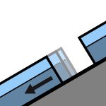
Recent reports of loose wet avalanches in steep South facing terrain. Although small, they were very easily triggered. Moderate westerlies and very warm. FAFL 3000m. Avoid shady aspects first thing unless prepared with the appropriate equipment.
Summer like heat is making its way into all aspects and elevations at the moment. Even normally shady areas - South aspects at upper elevations - are becoming wet in the afternoons. Expect a crust in the morning that will break down quickly in all areas.
Quelle: New Zealand Avalanche Advisory · Original-Lagebericht ansehen
Original (EN)
Häufige Fragen
Was bedeutet Lawinengefahrenstufe 2 (Mäßig)?
Erhöhte Lawinengefahr an einigen Steilhängen — sorgfältige Routenwahl und Geländebeurteilung sind nötig.
Wie oft wird der Lagebericht für Queenstown aktualisiert?
Avycast aktualisiert stündlich; New Zealand Avalanche Advisory veröffentlicht den Lagebericht in der Saison meist einmal täglich neu.
Wer veröffentlicht den Lawinenlagebericht für Queenstown?
New Zealand Avalanche Advisory — der offizielle Lawinenwarndienst. Avycast bündelt und übersetzt ihn; prüfe immer den Originalbericht.
Regionen in der Nähe
- Wanaka · 28 km
- Aspiring · 53 km
- Fiordland · 91 km
- Ohau · 101 km
- Aoraki/Mt Cook · 173 km
- Two Thumbs · 188 km