 AVYCAST
Wanaka — Avalanche Forecast
Avalanche danger in Wanaka (New Zealand) is 2 — Moderate, valid for Sunday, October 11, 2026. Published by New Zealand Avalanche Advisory.
Showers, warm temperatures and an elevated freezing level (2600m rising to 3000m). Expect a moist soft snowpack underneath a shallow surface freeze. Wet slide activity (Loose Wet and Glide) is possible. These slides are most likely to occur on North facing slopes but may also occur on other aspects. Watch for signs of growing instability such as point releases and rafting.
Danger by Elevation
Active Avalanche Problems

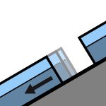
No avalanche activity reported recently. If you see evidence of avalanches in the back country please enter a Public Observation. Sunday - mostly fine with perhaps the odd shower. Strong North/North West winds turning Westerly and easing. Freezing level - 2600m climbing to 3000m in the afternoon. Spring conditions (melt/freeze) generally result in an elevated sliding hazard. Slick crusts and icy areas have been widespread especially, below about 1900m. Recommend carrying ski crampons and/or an ice axe and crampons.
Some rain on snow in the West of the region over the past 48hours. We now have a typical Spring snow pack with a melt/freeze cycle occurring. The underlying snow pack above about 1800m is mostly well settled. The snow pack below about 1800m is likely to be holding a significant amount of moisture underneath a shallow surface freeze.
Source: New Zealand Avalanche Advisory · View Original Bulletin
Original (EN)
Frequently asked questions
What does avalanche danger level 2 (Moderate) mean?
Heightened avalanche conditions on some steep slopes — careful route selection and terrain evaluation are needed.
How often is the Wanaka forecast updated?
Avycast refreshes hourly; the bulletin is republished by New Zealand Avalanche Advisory usually once a day during the season.
Who publishes the Wanaka avalanche forecast?
New Zealand Avalanche Advisory — the official warning service. Avycast aggregates and translates it; always check the original bulletin.
Nearby Regions
- Aspiring · 25 km
- Queenstown · 28 km
- Ohau · 90 km
- Fiordland · 98 km
- Aoraki/Mt Cook · 156 km
- Two Thumbs · 176 km