 AVYCAST
Wanaka — Boletín de aludes
El peligro de aludes en Wanaka (Nueva Zelanda) es 2 — Limitado, válido para domingo, 11 de octubre de 2026. Publicado por New Zealand Avalanche Advisory.
Traducción en curso — mostrado en idioma original
Showers, warm temperatures and an elevated freezing level (2600m rising to 3000m). Expect a moist soft snowpack underneath a shallow surface freeze. Wet slide activity (Loose Wet and Glide) is possible. These slides are most likely to occur on North facing slopes but may also occur on other aspects. Watch for signs of growing instability such as point releases and rafting.
Peligro por cota
Problemas de aludes activos

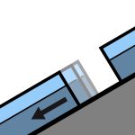
No avalanche activity reported recently. If you see evidence of avalanches in the back country please enter a Public Observation. Sunday - mostly fine with perhaps the odd shower. Strong North/North West winds turning Westerly and easing. Freezing level - 2600m climbing to 3000m in the afternoon. Spring conditions (melt/freeze) generally result in an elevated sliding hazard. Slick crusts and icy areas have been widespread especially, below about 1900m. Recommend carrying ski crampons and/or an ice axe and crampons.
Some rain on snow in the West of the region over the past 48hours. We now have a typical Spring snow pack with a melt/freeze cycle occurring. The underlying snow pack above about 1800m is mostly well settled. The snow pack below about 1800m is likely to be holding a significant amount of moisture underneath a shallow surface freeze.
Fuente: New Zealand Avalanche Advisory · Ver boletín original
Original (EN)
Preguntas frecuentes
¿Qué significa el nivel de peligro de aludes 2 (Limitado)?
Peligro elevado en algunas laderas empinadas — se requiere una elección de itinerario y una evaluación del terreno cuidadosas.
¿Con qué frecuencia se actualiza el boletín de Wanaka?
Avycast se actualiza cada hora; New Zealand Avalanche Advisory vuelve a publicar el boletín normalmente una vez al día durante la temporada.
¿Quién publica el boletín de aludes de Wanaka?
New Zealand Avalanche Advisory — el servicio oficial de alerta. Avycast lo agrega y lo traduce; consulta siempre el boletín original.
Regiones cercanas
- Aspiring · 25 km
- Queenstown · 28 km
- Ohau · 90 km
- Fiordland · 98 km
- Aoraki/Mt Cook · 156 km
- Two Thumbs · 176 km